
In the morning we confirmed our thoughts of driving across Nevada on Highway 50, known as the “Loneliest Road in America” and set off at 9:50. Part of this road was the route of the old Pony Express. Gillian found it worth a smile as we encountered a US Postal Service van then a UPS truck on the same road.


We made excellent progress, though keeping our speed to 55 0r 60 MPH in order to see what mileage we could get (about 10 US MPG) over the distance.
About half way across we began to run into mountain ranges: Grind up hill, sometimes for miles, then down again, then miles of flatland at the bottom and back up hill to do it all over again.


 The town of Austin looked to be an interesting place, we almost regret not stopping. We were a bit pushed for time as this was one long road. In retrospect we should have stopped. As we approached town we got behind a huge hay truck grinding up about 6 miles of hill!

 At the top of the hill the truck pulled over. Soon we were going back down the other side which led us to a very long straight stretch. Almost time for a nap.
The scenery was interesting, the variety making the drive easy. Good thing too as we arrived at the Silver Slag RV Park in Eureka Nevada at 5:30 PM after 771 kilometers and almost 9 hours of driving.
Nevada to Utah
Friday, October 21 we departed minutes before 9:00 AM. It had been a very cold night but was warming fast in the sun. Even the heavy 50Amp power cord had warmed enough to be fairly easy to coil back into the bin.
We were heading into what might be another long day. Moab, Utah, was where we planned to spend a couple of days in an RV Park doing laundry, catching up on e-mails, banking and the blog. Moab however is a loooooong drive from here. Not sure we want to too many more of those. Not really planning to reach Moab today, we'll just see how close we get and so have a short run tomorrow.


 Still long hills, though not quite so much, and lots of long relatively flat country. Geology lessons continued as the many soil and rock layers were exposed. (Click the photo to enlarge it then use the Back Arrow to return to the blog)


 110 miles later we crossed into Utah. Just before the border we stopped for fuel, then for lunch at Summit Pass at 6280 feet. From here we continued on the 50 until it met I 15 which we followed north for 10 miles or so where the 50 cuts off to the south-west for a while to the join the I 70; 126 more miles to the exit for highway 191 which we would follow to Moab then later our route to Bluff.
The road was for the first part slow curves and gentle hills. We were sure we had taken this stretch before but nothing was familiar. It was 100 miles later when we came across the exit for Highway 6. that the lights came on: the last time we followed I 70 to Moab we had come from Provo, Utah, and taken the 6 to the I 70.

The road atlas showed three Rest Areas on the I 70, the “Next Exit” mentioned several Rest Areas and View Areas at near the same locations. The GPS notified us of upcoming View Areas. We planned to stop for a break for the dogs at one of these Rest Areas but it wasn't there!
The geology was changing as we entered mesa and canyon country that Utah is famous for and that we love so much.


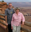
 About 80 miles before our turnoff for Moab we pulled into a View Area at Mile 104 for a stretch and some photos then carried on, thinking that we would probably stop for the night at the next one 20 or 30 miles further along I 70.


We found the next area as advertised but as we pulled in a sign directed Trucks to the left, the truck parking was only a wide loop just off the freeway. Cars were directed to the right where a narrow road wined up the hill between the rocks. Discretion being the better part etc etc we pulled back onto the road and carried on. Hoping that the next and last Rest Area would be where the atlas and the book said it would be, otherwise it might be a night drive to Moab!


 With the sun almost at the horizon we were getting close. We were now, and had been for some time, in the midst of starkly beautiful geological formation for which Utah is famous and that we love so much. They looked so much different in the evening light. We weren't even put off by the highway sign.

 Shortly after descending this cut, At 7:00 PM, at Mile Marker 180, we found our Rest Area. Not only recognizing it as where we had spent the night some years before, we also parked in the same space up alongside the bank where we could put the slide out with out risking passing traffic.
We got out for a stretch, the dogs as well, took some more photos (the motorhome pic was taken the next morning), set up the satellite, watched the news, had dinner and went to bed. 691 kilometers today. Tomorrow, Moab.


No comments:
Post a Comment