17th
KENTUCKY
With nothing exciting to hold us at the Walmart parking lot we were on the road by 10:30. This was not to be a day of freeways and interstates, though highway 16 at the start of the day was a pretty good road. Highway 52 was in good enough condition but narrow and twisty. Today we were driving through the valleys and bottom lands or "coves" in the vernacular. The map covers the first half of today's drive.
Click on any picture to enlarge it then use the back arrow to return to the page.


The scenery here was different from what we had been seeing--the forests up close as we travelled through small less affluent communities, frequently alongside small streams.


We stopped for fuel and to refill with water in the town of South Williamson just into Kentucky about 2:20. It took 10 minutes to fill with fuel and another 20 minutes to fill the fresh water tank!


An hour plus more and we finally stopped for a very late lunch in Pikeville Kentucky at 3:30.
The scenery along the way much the same, very much worth looking at. We were particularly glad that we noticed the sign directing trucks to the right. Our vertical clearance is 12 feet. 11 inches to spare!

This is coal mining country and has been for many many years. There is still a lot of mining activity in the area. There were a lot of very large trucks on these small winding roads. In one town we had to wait a good many minutes for a coal train to pass a level crossing.

This map shows our route for the rest of our day's journey after our lunch break.


We carried on through the hills and valleys of Kentucky, planning our overnight stop at Walmart in the town of Hazard. The drive continued to be very interesting and picturesque, or as Gerald would say "pictureskew".

Approaching our destination, eyes peeled for direction signs we came upon this one that had us somewhat concerned. Or rolling on the floor laughing!

 We turned off on what the GPS said was the right turn but quickly realised we were not where we should be. We made a few turns and backtracks and finally asked for directions when the GPS said that Walmart was 35 miles away! The advice didn't seem to help a lot so we asked someone else. This time we were lucky--two lefts and a right later and we were in the Walmart lot with permission to stay the night. Which was reasonably comfortable except for the semis hitting the jake brakes as they decelerated down the hill. Also the one tiny bump in the otherwise flat landscape seemed to block the Starchoice satellite!
18 October


 At 1015 we left Walmart on our way to Tennessee.
We planned to cross at the historical Cumberland Gap. The coal mining industry continued through this area, the country side much the same as yesterday. Including coal laden trucks in front of us.


We carried on enjoying the scenery and the "odd" interesting highway sign. We hoped this one (far right) wasn't a sign of things to come. (Click and click again to read the sign--use back arrow to return.)


At 1:45 we took a 1 hour break at the Cumberland Gap Info Center to walk the dogs and make lunch. This gap in the Cumberland Mountains, though still some 5000 feet in elevation, was the only pass in several hundred miles. Its discovery saved a lot of time and effort.
TENNESSEE

Next morning we set off for Tennessee through the Cumberland Gap. Unfortunately the Road Atlas, in fact all three that we have, cut up the state of Tennessee in such a way that we could not get a map photo of our complete route. We came through the Gap on highway 32 then the I-40 to highways 66 and 441 to the town of Pigeon Forge.


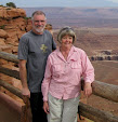
The drive was pleasant and uneventful, we pulled off a few times to better appreciate the view, terrain, countryside, whatever you want to call it.


And more tranquility and beauty.

Fortunately Gillian is an excellent navigator and was able to give the driver correct instructions as we came upon this signpost.


 We continued to enjoy the drive and the scenery until entering the city area: SLOW almost parking lot traffic along the strip, the roadside "attractions" the epitome of Tacky! In fact we call it Tackyville.

About an hour of stop and go shuffling along we arrived at arrive King's Holly Haven RV Park at about 17:45 where we booked in for 2 nights. Our neighbour was already in the hallowe'en mood.

In the morning, right after breakfast Gillian prepared our dinner, a lamb shank in the crock pot that would cook un-attended while we explored by car New Found Gap in the Great Smokey Mountains to the Tennessee/North Carolina State Line.


Here are some pics of today's trip.
.


And some more.

 And still more.


No comments:
Post a Comment