
The map to the right shows the roads and some of the communities traveled on this post. We left Fairbanks with full fuel and decided to top up in Tok where it took only 20 US Gallons (75.7 L). It later proved that we could have made it all the way to Whitehorse on the one tank with 20 litres (one 5 gallon can) to spare! At Whitehorse we needed 234.3 litres to fill the 330 litre tank. Glad we topped off in Tok or we would have had to buy very expensive fuel somewhere along the way. Cheapest diesel in Whitehorse is at the Tempo just north of the city at $1.07 per litre.


Before we had completely left the Fairbanks area we stopped in the suburb of North Pole for a bit of early Christmas shopping and to take a photo or two.
At Santa Clause House there is a corner of the shop that is an official US Post Office. It is here that mail addressed to Santa Clause, North Pole, is delivered. There are several examples of letters to Santa on the wall.

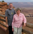
 By 3:20 we had arrived at Delta Junction, so called for its position at the top of the triangle formed by the Richardson, Alaska and Tok Cut Off highways so we stopped at the info centre for a sandwich in the rig and a few photos. We had to have a pic of AbqL at the end point of the Alaska Highway, mile 1,422 and one of Gillian next to life size replicas of some of the local wildlife.
At Delta Visitor's Center we met a couple from Surrey, B.C. who told us that they have had nothing but sunshine since leaving Surrey, BC 8 days previously. We were enjoying our 3rd consecutive sunny day, the longest sunny period for us since leaving home June 12th.

 Shortly after leaving Delta we had 10 miles of gravel where the highway was being resurfaced. At 40 mph the road was fine. Along the way we spotted a cow moose browsing along the forest edge but were almost too late for a picture--if you look carefully at the photo on the far left (click to enlarge) you can see the blurred image just into the right third of the photo as she heads into the bush . It was much better in real time! As usual the scenery was a combination of mountain, flat valleys and water; lakes, ponds, marshes, rivers and creeks.
We arrived in Tok at 7:30, pulling into the Chevron to top up with diesel. We would dry camp in the open field behind the station. We took only 20 US gallons, averaging on this leg 10.7 mpg (US). We won't do anything near to that on the Taylor highway to Chicken and Top Of The World to Dawson.

There were a couple of options for dinner to night, eating in not being one of them! First we checked out the Gumpy Griz which had essentially an assortment of fried food. Across the street was a Westmark hotel which on investigation had a very nice menu and an assortment of draught beers and ales.
They had an extensive array of Mexican dishes on the menu, though we didn't choose any those; They have 3 Mexican cooks in the kitchen who come up for the summer season!
Back at rig we entered some blog data into the word processor until such time that we would have a decent internet connection. However we did have our Starchoice TV signal so we were able to watch the news from CHEK. Still very light outside at 11:00 at night.
In the morning we checked at the info centre for road conditions on the Taylor Highway to Chicken and the junction with the Top Of The World Highway to Dawson City. This highway is gravel from just south of Chicken and for a lot of the way runs though riverbed. Much of the Taylor highway is built on rock and gravel tailings left behind from former gold dredging operations and the road bed is quite unstable. It had been washed out weeks ago and we discovered that it had reopened on Thursday. Today was Sunday.

By 10:00 AM we were on our way, determined to at least check it out. The Taylor Highway was slow and winding with a lot of hills with a few bad frost heaves and potholes but we enjoyed the scenic drive. Today was going to be a hard one as there would be little opportunity to use the cruise control.


The run to Chicken took two hours so at noon we pulled in for a look around and a pee break for the dogs. There is a story going around about the name: It's said that they were going to call it “Ptarmigan” but no one knew how to spell it! In the restaurant Art bought a mug of potato and mushroom soup and a travel mug of a double Americano to go.

 From just before Chicken onwards the road was gravel, several section recently repaired from severe washouts.The road was posted as "Single Lane Road" and it certainly was in places. At one point it took all of Art's attention to keep the right side wheels from sliding through the very soft shoulder into the ditch and avoiding the mirrors and side of a large 5th wheel that was south bound.
Note the speed caution sign in the photo to the far right. Art didn't have to slow any to obey this sign -- 30 mph!


Then we came upon this sign. (right) You mean we have been driving on undamaged road? But the scenery was still nice!


Much of the road followed the river valleys and in some cases followed the river bed! Here the river had washed away the road which ran right up the middle of the river bed, the river flowing on both sides of the road.
Some sections were in pretty good shape, the road straight and level though very dusty.


We were through Canada Customs after successfully answering the usual questions, who, what where, when (though not “why”) and we were back on paved road. We pulled into the first rest area-view point for lunch break and more photos.
The photo on the near left shows the Customs building in the distance. (click these pics for the best effect)

 The stark landscape was very beautiful and moving. Both the long view and the close up were wonderful to see. The lichen covered rocks are less that a foot in diameter. The photo of the flowers and berries covers about one square foot.

 Our one hour stop immediately became a two hour stop as we were now on Pacific Daylight Time. By 4:45 we were moving eastwards towards Dawson City. The road was in relatively good shape a few long sections of fresh gravel as the road was being chip sealed. Fortunately we missed the oil adding part!
Soon we had Dawson City in sight on the east side of the Yukon River. One more obstacle to overcome. We had it easy, a ferry (of sorts) running 24 hours a day during the summer. It shut down for the winter and the route to Alaska would then be the long way round, south to the Alaska Highway near Whitehorse—our next leg of our journey.


No comments:
Post a Comment